| [1] |
MüLLER-MAGUHN A , POITRAS L , ROSENBACH M ,et al. Treasure map:the NSA breach of telekom and other German firms[J]. Feedback, 2014,12:13.
|
| [2] |
LEE N , PLAN X , GENERATION Z . Counterterrorism and cybersecurity[M]. Berlin: SpringerPress, 2015: 301-319.
|
| [3] |
KSHETRI N . Kaspersky lab:from Russia with anti-virus[J]. Emerald Emerging Markets Case Studies, 2011,1(3): 1-10.
|
| [4] |
MIAO C C , WANG J L , ZHUANG S Y ,et al. A coordinated view of cyberspace[J]. arXiv Preprint,arXiv:1910.09787, 2019.
|
| [5] |
JIANG B , ORMELING F J . Cybermap:the map for cyberspace[J]. The Cartographic Journal, 1997,34(2): 111-116.
|
| [6] |
张峥 . 赛博地图构建理论研究[D]. 郑州:信息工程大学, 2012.
|
|
ZHANG Z . The research on theory of cybermap[D]. Zhengzhou:Information Engineering University, 2012.
|
| [7] |
GUONIAN L ü , LIN W Y , ZHAO Y U . Surveying and mapping geographical information from the perspective of geography[J]. Acta Geodaetica et Cartographica Sinica, 2017,46(10): 1549-1556.
|
| [8] |
郝梁 . 电子地图与地理信息系统[J]. 电子技术与软件工程, 2019(11):249.
|
|
HAO L . Electronic map and geographic information system[J]. Electronic Technology & Software Engineering, 2019(11):249.
|
| [9] |
BATTY M . Virtual geography[J]. Futures, 1997,29(4/5): 337-352.
|
| [10] |
BAKIS H . Understanding the geocyberspace:a major task for geographers and planners in the next decade[J]. Netcom, 2001,15(1/2): 9-16.
|
| [11] |
KUIPERS J H , . Analyzing the K-root DNS anycast infrastructure[C]// Twente Student Conference on IT. 2015: 1-6.
|
| [12] |
HUFFAKER B , PLUMMER D , MOORE D ,et al. Topology discovery by active probing[C]// 2002 Symposium on Applications and the Internet (SAINT) Workshops. IEEE, 2002: 90-96.
|
| [13] |
FUKUDA K , CHO K , ESAKI H . The impact of residential broadband traffic on Japanese ISP backbones[J]. ACM SIGCOMM Computer Communication Review, 2005,35(1): 15-22.
|
| [14] |
SHANNON C , MOORE D . The spread of the witty worm[J]. IEEE Security & Privacy, 2004,2(4): 46-50.
|
| [15] |
MAHADEVAN P , KRIOUKOV D , FOMENKOV M ,et al. The Internet AS-level topology:three data sources and one definitive metric[J]. ACM SIGCOMM Computer Communication Review, 2006,36(1): 17-26.
|
| [16] |
KEYS K , HYUN Y , LUCKIE M ,et al. Internet-scale IPv4 alias resolution with MIDAR[J]. IEEE/ACM Transactions on Networking (TON), 2013,21(2): 383-399.
|
| [17] |
JIANG J , XU X L , CAO N . Research on improved physical topology discovery based on SNMP[C]// IEEE International Conference on Computational Science and Engineering. IEEE, 2017: 219-222.
|
| [18] |
IRWIN B , PILKINGTON N . High level internet scale traffic visualization using hilbert curve mapping[M]. Berlin: SpringerPress, 2008: 147-158.
|
| [19] |
ORENSTEIN J A , MERRETT T H . A class of data structures for associative searching[C]// The 3rd ACM SIGACT-SIGMOD Symposium on Principles of Database Systems. ACM, 1984: 181-190.
|
| [20] |
FALOUTSOS C . Gray codes for partial match and range queries[J]. IEEE Transactions on Software Engineering, 1988,14(10): 1381-1393.
|
| [21] |
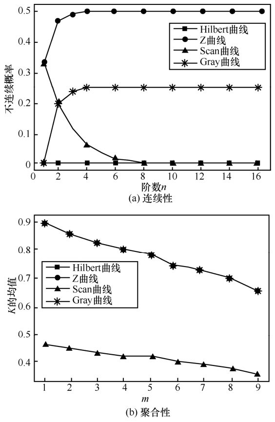
MOON B , JAGADISH H V , FALOUTSOS C ,et al. Analysis of the clustering properties of the hilbert space-filling curve[J]. IEEE Transactions on Knowledge and Data Engineering, 2001,13(1): 124-141.
|
| [22] |
贾奋励 . 电子地图多尺度表达的研究与实践[D]. 郑州:信息工程大学, 2010.
|
|
JIA F L . Research and practice of multiscale expression of electronic maps[D]. Zhengzhou:Information Engineering University, 2010.
|
| [23] |
DURUMERIC Z , WUSTROW E , HALDERMAN J A . ZMap:fast internet-wide scanning and its security applications[C]// USENIX Security Symposium. 2013: 47-53.
|
| [24] |
ADRIAN D , DURUMERIC Z , SINGH G ,et al. Zippier ZMap:Internet-wide scanning at 10 Gbps[C]// Usenix Conference on Offensive Technologies. USENIX Association, 2014:8.
|
| [25] |
LIU S C , WANG J L , WANG H ,et al. WRT:constructing users’ web request trees from HTTP header logs[C]// 2019 IEEE International Conference on Communications (ICC). IEEE, 2019: 1-7.
|
| [26] |
CICALESE D , AUGé J , JOUMBLATT D ,et al. Characterizing IPv4 anycast adoption and deployment[C]// The 11th ACM Conference on Emerging Networking Experiments and Technologies. ACM, 2015:16.
|
| [27] |
LI H , HE Y , XI R ,et al. A complete evaluation of the Chinese IP geolocation databases[C]// 2015 8th International Conference on Intelligent Computation Technology and Automation (ICICTA). IEEE, 2015: 13-17.
|
| [28] |
POESE I , UHLIG S , KAAFAR M A ,et al. IP geolocation databases:unreliable?[J]. ACM SIGCOMM Computer Communication Review, 2011,41(2): 53-56.
|
| [29] |
GHARAIBEH M , SHAH A , HUFFAKER B ,et al. A look at router geolocation in public and commercial databases[C]// The 2017 Internet Measurement Conference. ACM, 2017: 463-469.
|
| [30] |
SONG J , XU K , SONG M ,et al. Credibility evaluation method of domestic IP address database[J]. Journal of Computer Applications, 2014,34: 4-6.
|
| [31] |
LI H , ZHANG P , WANG Z ,et al. Changing IP geolocation from arbitrary database query towards multi-databases fusion[C]// 2017 IEEE Symposium on Computers and Communications (ISCC). IEEE, 2017: 1150-1157.
|