电信科学 ›› 2010, Vol. 26 ›› Issue (12): 106-109.doi: 10.3969/j.issn.1000-0801.2010.12.028

• 研究与开发 • 上一篇    下一篇

CAPS卫星导航系统定位精度分析方法研究

杜晓辉1,2,施浒立1,2,刘成1,2,胡正群1   

  1. 1 中国科学院国家天文台 北京100012
    2 中国科学院研究生院 北京100049
  • 出版日期:2010-12-15 发布日期:2010-12-15
  • 基金资助:
    国家重点基础研究发展计划(“973”)项目基金资助课题

Study on Method of Analyzing the Positioning Accuracy of CAPS

Xiaohui Du1,2,Huli Shi1,2,Cheng Liu1,2,Zhengqun Hu1   

  1. 1 National Astronomical Observatories,Chinese Academy of Science,Beijing 100012,China
    2 Graduate University of Chinese Academy of Science,Beijing 100049,China
  • Online:2010-12-15 Published:2010-12-15

摘要:

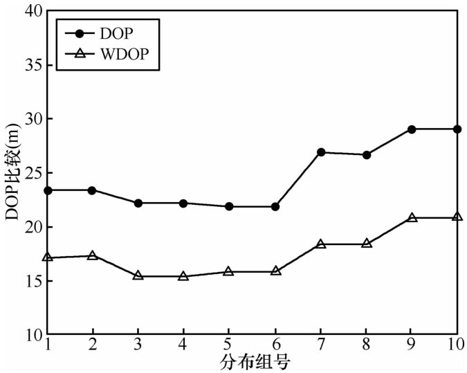
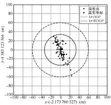
卫星导航系统的定位精度主要受伪距测量的精度和卫星的空间几何分布两方面的影响,GPS等相同轨道分布的卫星导航系统一般采用DOP(几何精度因子)来分析定位精度。我国的转发式卫星导航定位系统CAPS是由GEO商用通信卫星以及一定数量的倾斜轨道通信卫星(IGSO)组成的混合星座导航系统,转发地面控制站信号,实现导航定位等功能。由于不同轨道卫星轨道误差不同,用户得到的卫星轨位精度和测量伪距精度也不相同,因此定位精度计算时必须考虑这种差异。本文引入加权几何精度因子(WDOP)的概念,对CAPS 的定位精度进行了分析。通过仿真实验可以看出,由加权几何精度因子计算所得的定位精度能更真实地描述定位精度状况。

关键词: CAPS, 卫星导航, 定位精度, 灵敏度, 加权几何精度因子

Abstract:

Positioning accuracy of satellite navigation system is subjected to the influence of observation’s accuracy for pseudorange and the geometrical configuration of constellation.Generally GPS and other similar satellite navigation system using geometric dilution of precision(GDOP)to analyze the positioning accuracy.The transmitting satellite navigation and positioning system CAPS of our country is the mixed constellation navigation system,which is composed of GEO commercial communication satellites and a certain number of inclined geosynchronous orbit(IGSO)satellites.They are used to transmit signals from the ground station to realize like navigation and positioning.Due to the orbit errors for different orbit satellite,pseudo-range measurement accuracy the user received is not the same,so the difference must be considered when calculating positioning accuracy.The weighted dilution of precision(WGDOP)is introduced in this paper,we analyzed positioning accuracy of CAPS satellite navigation system.The simulation results show that positioning accuracy calculating from WDOP can be further improved when the user equivalent range error are the same.

Key words: Chinese area positioning system, satellite navigation, positioning accuracy, sensitivity, weighted dilution of precision

No Suggested Reading articles found!